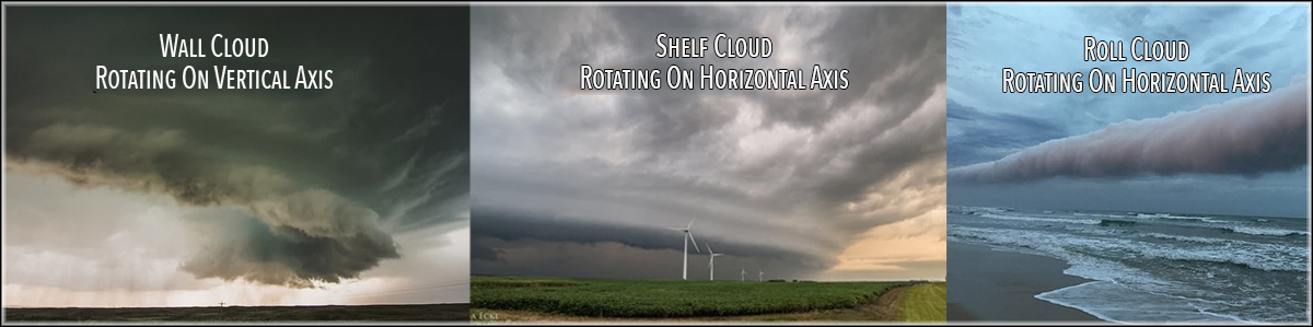
WALL CLOUDS - SHELF CLOUDS - ROLL CLOUDS
Real Ocean Cruisers survive year after year because they understand the weather.
Although they aren't meteorologists, they know how to read the clouds, and they understand what they are seeing.
They rarely get caught with too much sail up because they pay attention to the wind, water, and waves.
Real Ocean Cruisers recognize storm cells miles away, they understand what the clouds mean, and they prepare for what's coming.
I sailed entirely around the world without understanding the difference between wall clouds, shelf clouds and roll clouds, but I knew enough to avoid them like the plague.
Before I started on my circumnavigation, I remember watching a menacing roll cloud sweep across Chesapeake Bay, and in my heart of hearts, I was afraid. I didn't know how to the read the clouds. I knew the roll cloud was bad news, but I didn't know how bad it would get.
Many roll clouds later, I am no longer afraid.
When I see a roll cloud approaching, I am concerned, but I no longer quake in fear.
Here is what I learned about cumulonimbus clouds, storm cells, wall clouds, shelf clouds and roll clouds after many years at sea.
For the purposes of this discussion, storm cells, thunderstorms, and cumulonimbus clouds are all the same. They may come in small, medium and large varieties, but the principles that cause them to form are similar.
Every trade wind sailor examines cumulus clouds looking for vertical development. When the sun heats the atmosphere, convection causes warm surface air to rise. As the warm air ascends, it cools causing water vapor in the air to condense forming clouds.
When the updrafts are small, fair weather cumulus clouds dot the sky.
When the updrafts are strong, the cumulus clouds undergo vertical development.
When the updrafts are extremely strong, cumulonimbus clouds form with the cloud extending vertically over 60,000 feet and beyond. That's what creates severe storm cells and thunderstorms.
In the trade wind belts, cumulonimbus clouds generally have a dominant direction of travel, and if you turn on your radar, you can see where they are going.
Storm cells also have a front and back side.
On the front side, you see shelf clouds, roll clouds, and a high altitude overhanging anvil created by high level winds blowing the top off the storm.
As a thunderstorm approaches, you first see the high altitude anvil, then lower mammatus clouds followed by roll clouds and shelf clouds.
Positive lightning frequently originates out in front of the storm from the high altitude anvil, and negative lightning tends to originate from the storm cell's base.
The anvil cloud usually passes over you before the bottom of the cell arrives at your location.
Some storm cells lean forward in the direction of travel, and others not so much.
A storm cell receives it energy from ascending warm updrafts. When warm air reaches a high altitude, it becomes cold, and starts to descend. In a well-developed cumulonimbus cloud, cold air can descend at 70 miles per hour creating a microburst.
The main difference between a shelf cloud and a roll cloud is that the shelf cloud is attached to the leading edge of the thunderstorm, whereas a roll cloud is out in front of and is detached from the storm cell's base.
Roll clouds and shelf clouds are associated with gust fronts on the front side of the storm. These are the squall lines that cause unprepared sailors such grief.
Shelf clouds and roll clouds form when cold air inside a storm cell descends and spreads out on the ground lifting up warm moist air ahead of the storm.
As warm air is pushed up by the wedge of cold air, the water vapor in the warm air condenses, and a shelf cloud is born.
When the outflow of cold air interacts with warm moist air far in front of the thunderstorm, a roll cloud forms detached from the base of the storm.
In a roll cloud, lower level cold air moves in the opposite direction to upper level warm moist air, and the resulting wind shear creates a roll cloud that rotates on a horizontal axis at the interface of the cold and warm air.
If there is any rotation in a shelf cloud or roll cloud, it will be around a horizontal axis. Virga may extend downward from the base of shelf clouds and roll clouds, but it's rare for a tornado to form from these clouds. If a tornado forms, it tends to be weak and short lived.
A wall cloud is different because it's more centrally located in the base of the storm relatively far from its edge. A wall cloud is an abrupt lowering of a circle of clouds from the base of the storm cell, and it's where tornados form. The wall cloud is the location of strongest updrafts, and if the wall cloud rotates, it will rotate around a vertical axis.
Shelf clouds and roll clouds are associated with strong winds called squall lines.
Sometimes it's confusing to figure out if you are looking at a shelf cloud or a wall cloud.
When you face the storm cell, if the wind is in your face, that means you are looking at a shelf cloud created by downdrafts and outflow.
On the other hand, when you face the storm cell, if the wind is on your back, you are looking at a wall cloud because wind is rushing in to the center of the storm feeding the updrafts.
Here are the takeaways.
1. Roll clouds and shelf clouds are created by the same forces. One is attached to the base of the storm, and the other is detached from and out in front of the storm.
2. If roll clouds and shelf clouds rotate, they will rotate around a horizontal axis.
3. Roll clouds and shelf clouds create gust fronts known as squall lines with frequently damaging winds.
4. Roll clouds and shelf clouds put the wind in your face when you look at the center of the storm cell.
5. Wall clouds are areas of massive updrafts, and if the wall cloud rotates, it will rotate around a vertical axis.
6. Wall clouds are the area where serious tornados are most likely to form.
7. If you are close to a wall cloud, the wind will be to your back when you look at the center of the storm cell.
8. Negative lightning tends to come from the base of a storm cell.
9. Positive lightning tends to come from the high altitude anvil that spreads out in front of the storm.
10. Do your best to avoid sailing under the overhanging storm cell anvil where there is a greater risk of being struck by positive lightning. Positive lightning is ten times more powerful and lasts ten times longer than its negative counterpart.
Once you understand the anatomy and natural history of storm cells, you know what to expect, and you make timely preparations.
If you are really clever, you change your course and stay out of harm's way.


Awesome music video that captures the essence of what it's like to sail offshore in a catamaran around the world when conditions are less than perfect. David Abbott from Too Many Drummers sings the vocals, and he also edited the footage from our Red Sea adventures. This is the theme song from the Red Sea Chronicles.
Sailing up the Red Sea is not for the faint of heart. From the Bab al Mandeb to the Suez Canal, adventures and adversity are in abundance. If you take things too seriously, you just might get the Red Sea Blues.
If you like drum beats, and you like adventure, then have a listen to the Red Sea Chronicles Trailer.
Flying fish assault Exit Only in the middle of the night as we sail through the Arabian Gulf from the Maldives to Oman. And so begins our Red Sea adventures.
Sailing through Pirate Alley between Yemen and Somalia involves calculated risk. It may not be Russian Roulette, but it is a bit of a worry. Follow Team Maxing Out as they navigate through Pirate Alley.
Stopping in Yemen was just what the doctor ordered. We refueled, repaired our alternator, and we made friends with our gracious Yemeni hosts. We also went to Baskins Robbins as a reward for surviving Pirate Alley.
After you survive Pirate Alley, you must sail through the Gate of Sorrows (Bab Al Mandab) at the southern entrance to the Red Sea. The Gate of Sorrows lived up to its name with fifty knots of wind and a sandstorm that pummeled Exit Only for two days. Life is good.
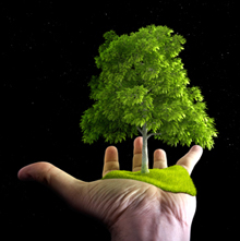
Although I like the feel of a paper book in my hand, I love trees even more. When people purchase an eBook, they actually save trees and save money as well. Ebooks are less expensive and have no negative impact on the environment. All of Dr. Dave's books are available at Save A Tree Bookstore. Visit the bookstore today and start putting good things into your mind. It's easy to fill your mind with positive things using eBooks. No matter where you are or what you are doing, you can pull out your smart phone or tablet and start reading. You can even use electronic highlighters and make annotations in your eBooks just like paper books.