DIGITAL DISASTER - LOST AT SEA
GPS came into its own when I lived in Saudi Arabia. Up until that time navigation was done mostly by compass and maps with an occasional resort to celestial navigation. In fact, I learned celestial navigation using a World War II bubble sextant in the Arabian desert.
We spent between sixty and ninety nights a year camping in the desert, and most of that time we didn't know our exact position on planet earth, and in practice it didn't matter. As long as we had plenty of fuel, maps, and compass, we could make it out of the desert without a problem
The only time our exact position became critical was when we planned a deep desert rendezvous with other Land Rovers. A successful rendezvous depended upon knowing their exact location. Even with a GPS, a successful rendezvous can be challenging when people set their GPS to different datum. You can go to the "same GPS location" and still be miles apart when you use a different datum.. I know this to be true because I once attempted a rendezvous with Land Rovers using the wrong GPS datum. We were more than a mile apart, and I didn't find the other vehicles until I changed my GPS to the correct datum. Not a big deal unless you are in tall sand dunes, and the other Land Rovers are on the other side of the dunes.
Safe navigation is more about strategy than it is about exact location.
Desert navigation is simple. When we went into the desert, we followed desert tracks that got progressively smaller as we went in. When it was time to exit, we followed progressively larger tracks until we emerged from the desert. We used our compass to make sure we were traveling in a straight line to prevent us from driving in circles as we headed out. Finally, we always navigated to a line rather than to a point when we were leaving. It’s easy to hit a line - a powerline, a road, an escarpment, a line of sand dunes when we exit the desert. It can be very hard to hit a specific point with desert navigation, so we always navigate to a line which makes it easy to find our way home.
Desert navigation was good preparation for navigating on Exit Only.
It made me understand that having a strategy was more important than knowing our exact location. Strategy is the important thing. The GPS location is a big help, but strategy is what keeps us out of trouble.
When I left Water World to work as a Flying Doctor on the Indian reservations of the American southwest, I experienced three dimensional navigation on a daily basis. Safely navigating an aircraft has more to do with strategy than it has to do with GPS location. We used visual flight rules 99% of the time, and we flew all around robin hood’s barn to get to and from our destination. We had to avoid thunderstorms, turbulence, forest fires, sand storms, microbursts and ice to safely reach our destination. Once again it was clear that safe navigation has more to do with strategy than exact GPS location.
Now that I am back in Water World, I discovered digital navigation. People now worship at the Altar of GPS, and their holy book is their chart plotter. Unfortunately, the GPS and the chart plotter are long on position and short on strategy.
It is not uncommon for people to sail their boat onto a reef while they stare at their chart plotter. If they had been on deck looking with their eyes, they would not have lost their yacht.
I observed sailors cruising the Bahamas banks at night in extremely thin water in total darkness betting their boat on the chart plotter. Their aquatic destiny depended 100% on the accuracy of the chart, and if the chart is old or outdated, their voyage ends in disaster.
Chart plotters don't reveal everything they know, and they frequently don't give up important information easily. What the plotter shows can vary significantly depending on the degree of zoom.. When you plan a challenging navigational route, you need to zoom in to higher level to make sure the lower levels of zoom don't obscure critical navigational information. If you are smart, you will compare the paper chart against the digital chart to confirm that your navigational plan is sound.
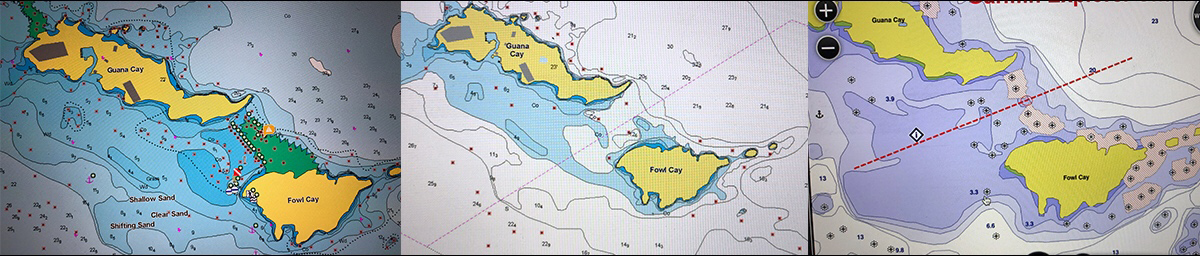
It has been said that lightning does not strike twice in the same place. The same cannot be said about digitally assisted disasters where multiple yachts are lost in the same location. Here are three different digital charts of the same location where two catamarans were lost. One was a new Lagoon 45 and the other was a 44 foot catamaran. The way these three charts represent the same area are seriously different, and a sailor using the middle chart will lose their boat to a reef.
I have too much invested in my catamaran to trust my sailing destiny to a chart plotter and digital charts. I trust my eyes, and if my eyes don't say go, then I stay put.
You can’t be in a hurry when you are sailing in coral, and there is no chart plotter in the world that can guarantee safe passage. You need a good set of eyes wearing polarized sun glasses with the sun overhead or behind your back to safely pass through coral infested waters.
It’s intoxicating to see your position progressing along on a chart plotter creating the impression that you are safe and navigating in a seaman like manner. You feel like a real mariner, but you are fooling yourself. You shouldn't be looking at the chart plotter. You should be looking at the sea with your polarized sunglasses.
When we sail Exit Only in thin water, we have someone on the bow guiding the yacht, and we go slow until we are 100% sure we are safe. On rare occasions, we put a crew member in the lower spreaders to visualize the path ahead. If spreader man can't see what's ahead, we stop. It's just not worth the risk.
Digital charts are great when they work, but I would rather trust my boat to my eyes rather than rely on my plotter.
Having a plotter may be better than nothing, but if your trust in your plotter without using your eyes, you may end up with nothing.
Your position is only as good as the electronic chart in front of your eyes. And electronic charts may be out of date, or just plain wrong.
When I am in questionable navigational territory, first, I look at the digital chart. Then I compare the digital chart to the paper chart to make sure they agree. If they disagree, then we are in a no go situation.
As a practical matter, I use the digital chart as a way of orienting myself to my surroundings telling me what I should be seeing. Then I look around Exit Only to see if what I am supposed to be seeing is really out there. This keeps me honest, and also keeps me out of harms way. When my chart plotter matches what I see in the real world, then I move cautiously forward, and if I make a mistake, it will likely be a small one.
Finally, when I am in a dicy navigational situation, I don't raise any sail until I am free and clear. If you hit a reef under full sail, it's game over. If you hit the same reef under power at half a knot, you have a good chance of saving your boat, especially if you are in a catamaran with two engines.
Don't let a digital disaster happen to you. Understand the limitations of your chart plotter and your digital charts.
Your eyes don't lie, and if your eyes don't know, you don't go.
That's my navigational strategy, and I am sticking with it.


Awesome music video that captures the essence of what it's like to sail offshore in a catamaran around the world when conditions are less than perfect. David Abbott from Too Many Drummers sings the vocals, and he also edited the footage from our Red Sea adventures. This is the theme song from the Red Sea Chronicles.
Sailing up the Red Sea is not for the faint of heart. From the Bab al Mandeb to the Suez Canal, adventures and adversity are in abundance. If you take things too seriously, you just might get the Red Sea Blues.
If you like drum beats, and you like adventure, then have a listen to the Red Sea Chronicles Trailer.
Flying fish assault Exit Only in the middle of the night as we sail through the Arabian Gulf from the Maldives to Oman. And so begins our Red Sea adventures.
Sailing through Pirate Alley between Yemen and Somalia involves calculated risk. It may not be Russian Roulette, but it is a bit of a worry. Follow Team Maxing Out as they navigate through Pirate Alley.
Stopping in Yemen was just what the doctor ordered. We refueled, repaired our alternator, and we made friends with our gracious Yemeni hosts. We also went to Baskins Robbins as a reward for surviving Pirate Alley.
After you survive Pirate Alley, you must sail through the Gate of Sorrows (Bab Al Mandab) at the southern entrance to the Red Sea. The Gate of Sorrows lived up to its name with fifty knots of wind and a sandstorm that pummeled Exit Only for two days. Life is good.
Although I like the feel of a paper book in my hand, I love trees even more. When people purchase an eBook, they actually save trees and save money as well. Ebooks are less expensive and have no negative impact on the environment. All of Dr. Dave's books are available at Save A Tree Bookstore. Visit the bookstore today and start putting good things into your mind. It's easy to fill your mind with positive things using eBooks. No matter where you are or what you are doing, you can pull out your smart phone or tablet and start reading. You can even use electronic highlighters and make annotations in your eBooks just like paper books.