


My Iridium Go satellite phone arrived in Panama six weeks before I made the passage from Panama to the Galapagos Islands, and I immediately began a crash course learning how to extract the maximum information from Predict Wind before I set sail.
The Perlas Islands offered an excellent opportunity to test how well the Predict Wind / Iridium Go system performed, and I spent one month in the Perlas learning the ins and outs of Predict Wind and Iridium Go.
LEARN PREDICT WIND / IRIDIUM GO BEFORE YOU SET SAIL
At least twice a day for a month, I downloaded every possible bit of information that Predict Wind had to offer. I wanted to see how well it predicted wind strength and direction, and I also had it do routing for me to the Galapagos. I downloaded water vapor and infrared satellite photos on a daily basis as well. By the time I left for the Galapagos, I had a thorough knowledge of how to use Iridium Go to extract weather information for the trip.
Here is what I learned:
WEATHER ROUTING
The basic package of Predict Wind does very well for trips of short duration - one or two days. If you want your computer to make a weather route for you, it will be a reasonable course to follow for one or two day trips.
If the voyage is significantly longer than a few days, the weather routing is less helpful. There are simply too many variables in the equation to predict the best route for an extended voyage.
PROBLEMS WITH WEATHER ROUTING
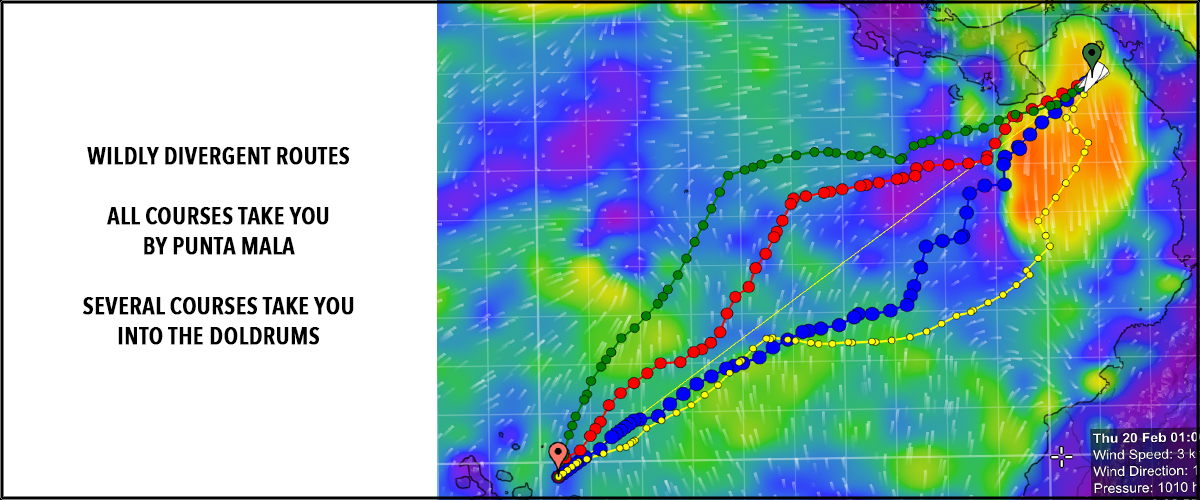
If you use Predict Wind routing from Balboa to Galapagos, it will take you by Punta Mala which is a bad place to sail unless you are want to learn how to manage your boat in adverse current with steep square waves, and you want to know if your boat is up to the task of sailing at speed in adverse conditions.
The Predict Wind routing navigated us through the doldrums, and if we had followed the recommended track we would have motored for hundreds of windless miles punctuated by fierce thunderstorms when there was favorable wind to the east.
It rapidly became clear that the program was biased in the direction of unlimited motoring and sailing was a secondary consideration. If my goal in reaching Galapagos was to motor for 400 to 500 miles through thunderstorms and rain, then I would have been extremely pleased with the recommended route.
PREDICT WIND DOES NOT KNOW MY BOAT OR HOW I SAIL
Predict Wind does not know how much fuel I carry on Exit Only, and what my range is using my engines. It also does not know how far I can motor when I have favorable or adverse currents. It does not know that avoiding thunderstorms in the doldrums was a high priority as I am not interested in vaporizing $10,000 in electronics as well as the autopilot in a lightning strike. It does not know that I sail my catamaran differently at night than in the day time. It does not know that the doldrums expand and contract on a daily basis, and a path through the doldrums could be very quick, or could be an excruciatingly miserable experience that goes on for days. The amount of information that Predict Wind does not know makes it impossible for them to make an acceptable customized 900 mile route for Exit Only to the Galapagos.
WEATHER MODELS HAVE LIMITED VALUE AFTER 3 DAYS
Predict Wind is based on publicly available weather information packaged in a format that can be transmitted to a yacht by satellite. The weather models used by predict wind do not know the future, and like all grib files, after three days out, the grib files become grib fantasies. Therefore it isn’t surprising that the weather routing for a six to ten day trip is not accurate, because after three days, the weather routing is a trip to fantasyland.
If your trip is in the trade winds for a thousand mile downwind run, then the routing will be relatively accurate beyond three days, but that is serendipity rather than the ability of the computer to look into the future.
DAILY WEATHER ROUTINE
On our trip to Galapagos, we downloaded weather routing every day, and we ignored it because it consistently sent us through the doldrums. We downloaded satellite photos, and we saw that we could avoid the doldrums and thunderstorms of the intertropical convergence zone by sailing well east of the recommended track.
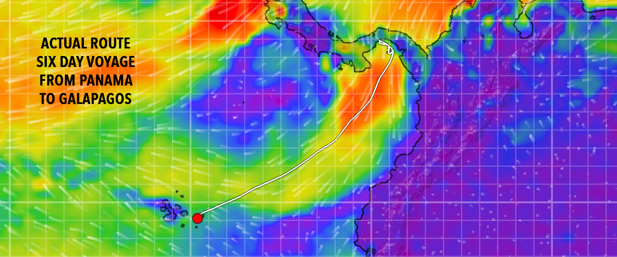
Strong winds from the north coming out of Panama were in the 12 to 25 knot range for the first four days of the trip, then lighter winds curved gently west toward Galapagos on a broad reach for the remainder of the trip.
On the entire 900 mile trip to the Galapagos, we were on a close reach for only six hours. The rest of the time we were on a beam reach, broad reach, or running downwind. The Predict Wind grib files were spot on, and when we created our own route using that information, we had a six day sail, and we totally avoided the doldrums. By the fourth day, we started seeing typical trade wind cumulus in the evening, and it became clear that we had made an end run around the doldrums.
EXCELLENT REPRESENTATION OF GRIB FILES
I give Predict Wind high marks for their graphic presentation of the grib files which were extremely accurate. In addition, the software placed our position on the grib file so we could see exactly where we are in the wind flow, and we could make a good decision about what direction to sail for the next 24 hours.

SATELLITE PHOTOS
The size of the intertropical convergence zone (doldrums) varies on a daily basis, and the associated weather disturbances (thunderstorms) expand and contract in an unpredictable fashion. The doldrums move east and retreat west over short periods of time. This is where the satellite photos came into their own. We downloaded water vapor and infrared satellite photos every day to see the width of the doldrums and location of the most intense thunderstorms. Based on satellite photos, we chose a course east of the doldrums and we never felt a drop of rain, saw a cumulonimbus could, heard any thunder, or observed a lightning strike during the entire voyage.
NO OCEAN CURRENTS WITH THE BASIC PACKAGE
A weakness of the Predict Wind package is that the basic package does not allow for downloads of ocean currents while underway. You need the professional package to be able to do that, and the professional package costs twice as much.
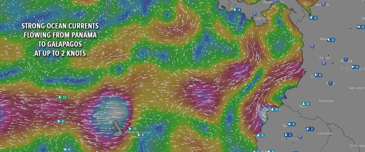
I wanted to know the current that we would encounter during the trip, and so for the week before we set sail, I looked at ocean currents on windy.com, and I took daily screenshots of the current that I could refer to during the Galapagos voyage. Those screenshots were extremely helpful because it identified the Panama current that flows at 1 to 2 knots from Panama to the Galapagos at this time of year. We stayed in that current for nearly the entire trip, and the conveyor belt of current added 2 knots of speed for Exit Only in the direction of the Galapagos. When we took down our sails and stopped the boat on the fourth day for a swim in the ocean, the GPS showed that we were still moving at 2 knots in the direction of Galapagos because we were riding the Panama current. When our boat was under sail, we were moving at 7 to 9 knots because the current was carrying us along.
The Panama to Galapagos current was actually responsible for the discovery of Galapagos by the Spanish in the 1500s. Their small ship had no wind in the doldrums, and the Panama current carried them to the Galapagos where they found water, but not until several of their crew had died of thirst. They did not boldly sail where no one had sailed before. Instead, they pathetically drifted in the current until they arrived in Galapagos, and they claimed the new islands for the Spanish Crown.
SAILMAIL HAS OCEAN CURRENTS FOR FREE DOWNLOAD
While Predict Wind does not offer downloads of ocean currents, we can download ocean currents from Sailmail. Software is now available to download Sailmail using Iridium Go, and if you request ocean currents on Sailmail, you can download them using Iridium Go.
The Iridium Go combined with Predict Wind and Sailmail are an excellent package, and they give you high quality information for the safest passage offshore.
UNLIMITED DATA AND UNLIMITED TEXTING
The Iridium Go unit has unlimited data downloads, and that means you can send and receive text messages for free. During our six day passage, we sent hundreds of text messages to maintain contact with family and friends. On evening watch, we might spend an hour or two texting back and forth to people halfway around the world.
CONCLUSIONS
On a scale of 1 to 10, I rate the Predict Wind package a solid 10. I didn’t find that their weather routing was helpful on this trip, but on future shorter trips it may be more helpful. The ability to download satellite photos to observe major weather systems is invaluable, and keeps us honest about the weather. Optimism has no place when it comes to forecasting bad weather, and a satellite photo brings us back to the real world and helps us make better weather decisions.
I recommend the Predict Wind / Iridium Go package to offshore sailors. It will make their voyaging safer, faster, and more fun, and you can’t ask for much more than that.


Awesome music video that captures the essence of what it's like to sail offshore in a catamaran around the world when conditions are less than perfect. David Abbott from Too Many Drummers sings the vocals, and he also edited the footage from our Red Sea adventures. This is the theme song from the Red Sea Chronicles.
Sailing up the Red Sea is not for the faint of heart. From the Bab al Mandeb to the Suez Canal, adventures and adversity are in abundance. If you take things too seriously, you just might get the Red Sea Blues.
If you like drum beats, and you like adventure, then have a listen to the Red Sea Chronicles Trailer.
Flying fish assault Exit Only in the middle of the night as we sail through the Arabian Gulf from the Maldives to Oman. And so begins our Red Sea adventures.
Sailing through Pirate Alley between Yemen and Somalia involves calculated risk. It may not be Russian Roulette, but it is a bit of a worry. Follow Team Maxing Out as they navigate through Pirate Alley.
Stopping in Yemen was just what the doctor ordered. We refueled, repaired our alternator, and we made friends with our gracious Yemeni hosts. We also went to Baskins Robbins as a reward for surviving Pirate Alley.
After you survive Pirate Alley, you must sail through the Gate of Sorrows (Bab Al Mandab) at the southern entrance to the Red Sea. The Gate of Sorrows lived up to its name with fifty knots of wind and a sandstorm that pummeled Exit Only for two days. Life is good.
Although I like the feel of a paper book in my hand, I love trees even more. When people purchase an eBook, they actually save trees and save money as well. Ebooks are less expensive and have no negative impact on the environment. All of Dr. Dave's books are available at Save A Tree Bookstore. Visit the bookstore today and start putting good things into your mind. It's easy to fill your mind with positive things using eBooks. No matter where you are or what you are doing, you can pull out your smart phone or tablet and start reading. You can even use electronic highlighters and make annotations in your eBooks just like paper books.