


A GPS DOES NOT MAKE YOU A NAVIGATOR ANY MORE THAN A BOAT MAKES YOU A SAILOR
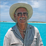
When Marvin Creamer was 66 year old, he set off on a circumnavigation on his steel hulled 36 foot sailboat named Globe Star.
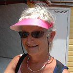
His circumnavigation took 513 days with stops for repairs and provisioning in Cape Town, South Africa, Hobart, Tasmania, Sydney, Australia, Wangaroa, New Zealand, Port Stanley in the Falkland Islands, and Bermuda.
Globe Star was an appropriate name for his boat since he planned to navigate around the world using stars.
His voyage was unique because he sailed without navigational instruments. He did not use a watch, a clock, a compass, a sextant or GPS (not invented yet). His goal was to prove you could circumnavigate without using navigational instruments.
He navigated by the wind, waves, sun, moon, and stars as well as paying attention to wildlife and clouds that indicated proximity to land.
Sailing without instruments had two main challenges.
He had to be able to sail a specific course without referring to a compass, and he had to be able to determine his latitude without using navigational instruments.
He had previously sailed twice across the Atlantic without using navigational instruments.
On one of his transatlantic voyages, his compass light did not work at night, and he maintained his course by keeping his boat at the same angle to the wind and waves. He used the sun and stars to determine direction, and he used the wind and waves to maintain his heading when he couldn’t see the stars.
During one of his Atlantic crossings, he lost his self-steering system, and he had to steer by hand. He stayed on course by looking at the stars near the horizon at night. In the daytime he steered a steady course by keeping his boat at the same angle to the wind and seas.
Sailing a course while staring at a compass is tedious and difficult. You often oversteer, and the course tends to wander. When you steer toward a star on the distant horizon, the course stabilizes and steering becomes easier.
Keeping the same angle to the wind and waves is easier than trying to maintain a precise compass heading when steering by hand.
Creamer checked his heading mid day by noting the location of the sun. At local noon, the sun is directly south if you are in the northern hemisphere, and the sun is directly north if you are sailing in the southern hemisphere.
Creamer navigated using latitude sailing to reach his destinations.
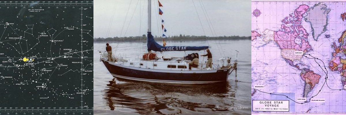
He used the declination of stars to determine latitude.
Stars have latitudes just like every geographic point on Earth.
Star latitudes are called declinations.
Earth’s equator has a latitude of zero degrees, and a star directly above the earth’s equator has a declination of zero degrees.
The north and south geographic poles have a latitude of ninety degrees, and a star directly above the geographic poles has a declination of ninety degrees.
The declination of Mintaka on Orion’s belt is zero degrees because it lies on the celestial equator. If you are sailing on the geographic equator, Mintaka will pass directly over your boat.
For every geographic latitude on planet Earth, there is a star with a similar declination.
If you want to navigate to a specific latitude, you sail north or south until a star passes directly overhead with the same declination as the desired geographic latitude.
Once you arrive at your desired latitude, you sail down that latitude until you reach your destination.
That’s exactly what Marvin Creamer did.
He had charts of planet Earth that showed the latitudes of his destinations, and he had star maps that showed the declination of stars.
He sailed to the latitude of his destination guided by stars.
He selected a star with a declination that matched the latitude of his destination.
Latitude sailing in northern hemisphere is made easier because the altitude of Polaris above the horizon is equal to latitude, and when you estimate of the height of polaris above the northern horizon, you can figure out your latitude within a degree or two (One degree equals sixty miles measured at the equator).
Polaris not only makes it easy to determine latitude, it’s a signpost in the sky that shows the direction of true north and its reciprocal true south.
There is no visible star lying over the geographic south pole, which makes it harder to determine latitude using the celestial south pole.
The Southern Cross is not located at the geographic south pole, but it acts as a pointer making it possible to determine the approximate location of the pole and the direction of true south.
If you have a star chart, a navigational chart, and a list of the declination of stars, you have all you need to make a circumnavigation of planet Earth.
Creamer’s navigational challenge was made easier by the fact that he made most of his trip in the southern oceans sailing south of all the great capes.
At the beginning of his trip he could use Polaris as the cardinal point on his celestial compass to point him south. Once he crossed the equator he could use the Southern Cross to guide him further on the passage south.
When he wanted to stop at a specific destination, he had to select a star that had a similar declination as the latitude of his destination.
The Cape of Good Hope is around latitude 56 degrees south, and the star Schedar has a declination of 56 degrees south. He simply navigated south until Schedar passed directly overhead at night, and he knew he would pass south of the Cape of Good Hope.
Cape Horn is close to latitude 35 degrees south, and the star Vega has a declination of 38 degrees south. If he navigated south until Vega passed directly overhead, he knew that he would pass at least 180 miles south of Cape Horn.
The Nautical Almanac and star charts record the declination of 57 navigational stars.
Creamer simply had to select and sail to a star that had a declination close to the geographic latitude of his destination.
At night he studied the constellations to identify navigational stars. Once he knew the name of the specific star that passed directly overhead, he knew his latitude.
His job as a navigator was to identify the star that passed directly overhead at midnight.
A single page from the Nautical Almanac listing the declination of the navigational stars told him everything he needed to know.
A Simex Star Finder also gives the declination of the navigational stars.
Creamer had other clues as to his latitude.
When he crossed the northeast trade wind belt in the Atlantic, the direction of the wind and waves told him his approximate location.
When he entered the windless doldrums, he also knew his approximate location.
When he crossed the southeast trade winds in the Atlantic, the direction of the wind and waves told him his approximate location.
When he finally reached the deep southern ocean with westerly wind and waves pushing him eastward around the world, he knew he had arrived in the southern ocean.
He knew he was approaching land when the color of the water changed, swells reflected off the land made their appearance, seabirds flew to and from land, and clouds appeared over the land in a different pattern than the clouds at sea.
Creamer proved it was possible to sail around the world without navigational instruments.
Most of us would rather use a GPS and make a direct course to our destination, and there is nothing wrong with that.
Unfortunately, a lightning strike can vaporize your GPS, and a military conflict can shut down the satellites that make GPS possible.
When that happens, it’s time to get out the star charts and do latitude navigation.
Of course, if you have a watch and a sextant, your navigational problem is easily solved. You can take a noon sight, a planet sight, or a star sight, and you will know your location within a few miles.
It’s important to remember that navigation is not about position.
Navigation is about how to proceed in a safe manner from a known location.
A GPS reveals your location, but it doesn’t tell you how to proceed.
While it’s nice to know your location, a real navigator can proceed in a prudent fashion to reach his destination without ever knowing his precise location.
Thousands of boat have been lost on rocks and reefs in GPS assisted disasters. They sailed into destruction while staring at their GPS.
A GPS does not make you a navigator any more than a boat makes you a sailor.
Addendum: Marvin Creamer made his last offshore voyage to Bermuda at 95 years of age with his son and two grandchildren. He passed away on the east coast at 104 years old.
Captain Dave

Awesome music video that captures the essence of what it's like to sail offshore in a catamaran around the world when conditions are less than perfect. David Abbott from Too Many Drummers sings the vocals, and he also edited the footage from our Red Sea adventures. This is the theme song from the Red Sea Chronicles.
Sailing up the Red Sea is not for the faint of heart. From the Bab al Mandeb to the Suez Canal, adventures and adversity are in abundance. If you take things too seriously, you just might get the Red Sea Blues.
If you like drum beats, and you like adventure, then have a listen to the Red Sea Chronicles Trailer.
Flying fish assault Exit Only in the middle of the night as we sail through the Arabian Gulf from the Maldives to Oman. And so begins our Red Sea adventures.
Sailing through Pirate Alley between Yemen and Somalia involves calculated risk. It may not be Russian Roulette, but it is a bit of a worry. Follow Team Maxing Out as they navigate through Pirate Alley.
Stopping in Yemen was just what the doctor ordered. We refueled, repaired our alternator, and we made friends with our gracious Yemeni hosts. We also went to Baskins Robbins as a reward for surviving Pirate Alley.
After you survive Pirate Alley, you must sail through the Gate of Sorrows (Bab Al Mandab) at the southern entrance to the Red Sea. The Gate of Sorrows lived up to its name with fifty knots of wind and a sandstorm that pummeled Exit Only for two days. Life is good.
Although I like the feel of a paper book in my hand, I love trees even more. When people purchase an eBook, they actually save trees and save money as well. Ebooks are less expensive and have no negative impact on the environment. All of Dr. Dave's books are available at Save A Tree Bookstore. Visit the bookstore today and start putting good things into your mind. It's easy to fill your mind with positive things using eBooks. No matter where you are or what you are doing, you can pull out your smart phone or tablet and start reading. You can even use electronic highlighters and make annotations in your eBooks just like paper books.